Even for a low-activity wiki, hosting & rendering many HQ image files takes significant resources and comes with high monthly server costs.
If you're able, please consider contributing to keep the site running to help support this independent, ad-free, fan-run site. Thank you!
Maps/Town: Difference between revisions
< Maps
No edit summary |
m Reverted edits by PawPatroler (talk) to last revision by Eli Tag: Rollback |
||
| (3 intermediate revisions by 2 users not shown) | |||
| Line 1: | Line 1: | ||
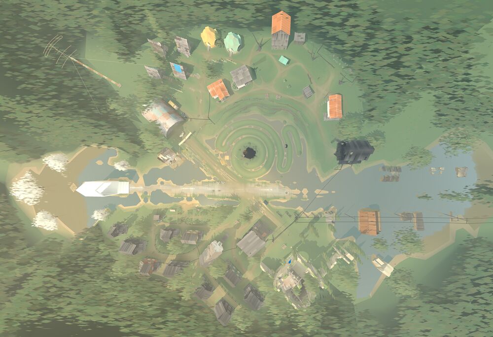
{{Map/Start|base=Town-Aerial. | {{Map/Start|base=Town-Aerial.jpg|width={{{width|1000}}}}} | ||
<!--{{Map/Grid|color=rgba(255, 255, 255, 0.5)}}--> | <!--{{Map/Grid|color=rgba(255, 255, 255, 0.5)}}--> | ||
{{Map/Label|22|56|[[5 Dogwood Drive]]|length= | {{Map/Label|22|56|[[5 Dogwood Drive]]|length=25|width=6}} | ||
{{Map/Label|34|46|[[WEVP-TV]]|length=20|width= | {{Map/Label|34|46|[[WEVP-TV]]|length=20|width=5.5}} | ||
{{Map/Label| | {{Map/Label|50.5|45.5|[[Silo of Late Reflections]]|length=20|width=6.5}} | ||
{{Map/Label|33|34| | {{Map/Label|33|34|Hangar|length=30|width=5}} | ||
{{Map/Label|43|76|Old church|length=20|width= | {{Map/Label|43|76|Old church|length=20|width=6}} | ||
{{Map/Label|60|84|Library|length= | {{Map/Label|60|84|Library|length=30|width=5}} | ||
{{Map/Label|72|45|Barn|length= | {{Map/Label|72|45|Barn|length=35|width=3.5}} | ||
{{Map/Label| | {{Map/Label|60.5|45|[[Earthwork path]]|length=40|width=6}} | ||
{{Map/Label|69|18|Graveyard|length=20|width= | {{Map/Label|69|18|Graveyard|length=20|width=6}} | ||
{{Map/Label|70|76|Bell tower|length=20|width= | {{Map/Label|70|76|Bell tower|length=20|width=6}} | ||
{{Map/Label|53|69|Cafe/Company Store|length= | {{Map/Label|53|69|Cafe/Company Store|length=30|width=7.5}} | ||
{{Map/Label|33|65|Garden|length=20|width= | {{Map/Label|33|65|Garden|length=20|width=5}} | ||
{{Map/Label|59|33|Small cave|length= | {{Map/Label|59|33|Small cave|length=15|width=6.5}} | ||
{{Map/Label|45|54|Mail stop|length=20|width= | {{Map/Label|45|54|Mail stop|length=20|width=5.5}} | ||
<!--Ash Alley--> | <!--Ash Alley--> | ||
<!-- | <!--"Ethnic quarter"--> | ||
<!--New quarter--> | <!--"New quarter"--> | ||
<!--Marsh quarter --> | <!--"Marsh quarter" --> | ||
{{Map/End}}<noinclude>[[Category:Maps]]<noinclude> | {{Map/End}}<noinclude> | ||
[[Category:Maps]]<noinclude> | |||
Latest revision as of 01:08, 27 April 2026
Hangar
Old church
Library
Barn
Graveyard
Bell tower
Cafe/Company Store
Garden
Small cave
Mail stop