Even for a low-activity wiki, hosting & rendering many HQ image files takes significant resources and comes with high monthly server costs.
If you're able, please consider contributing to keep the site running to help support this independent, ad-free, fan-run site. Thank you!
Difference between revisions of "File:Zero act2 clockwise.png"
Jump to navigation
Jump to search
(Added Summary and Directions.) |
|||
| Line 1: | Line 1: | ||
| − | + | == Summary == | |
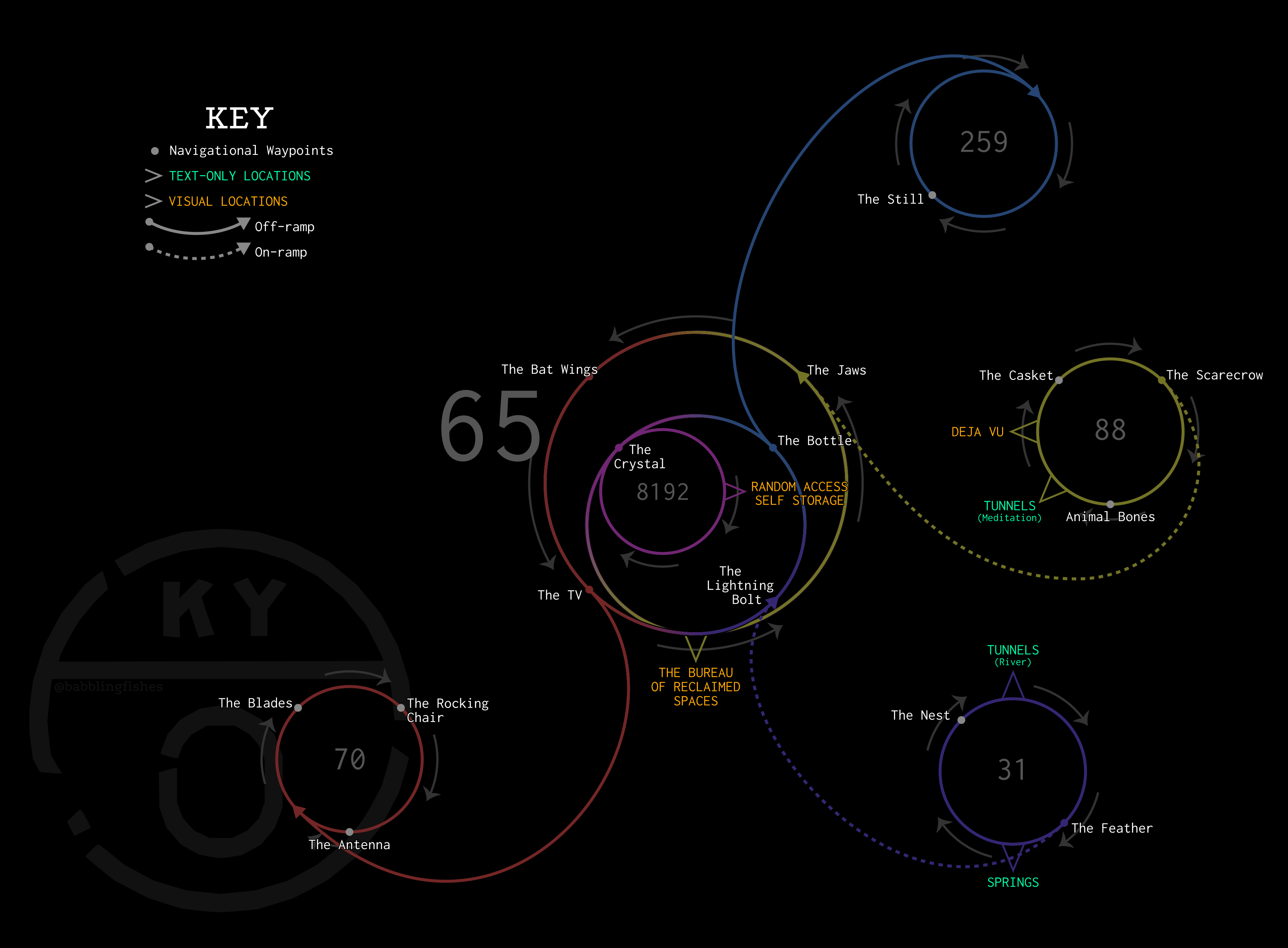
| + | A clockwise map of the Zero from Act 2. | ||
== Licensing == | == Licensing == | ||
{{self}} | {{self}} | ||
| + | == Directions == | ||
| + | * This map begins clockwise from the Bureau. Its [[File:Zero act2 counterclockwise.png|sister map]] begins counterclockwise. Pay attention to the arrows. | ||
| + | * This map is not proportional. All that matters is the direction you’re heading in and the waypoints you’ve passed. | ||
| + | * The on- and off-ramps connecting the 65 and outer roads are symbolic. ''They do not exist as a physical stretch of road.'' Just turn around at the proper waypoint to instantly switch roads. | ||
| + | * If you are not sure where a waypoint leads, stop in front of it and wait until the waypoint stops flickering. If it is an on- or off-ramp, you will hear a beep and a sign will appear with the route number that it leads to. | ||
| + | * Any waypoint that is not an on- or off-ramp can be safely used for u-turns. If you pull a u-turn, switch maps. | ||
Revision as of 19:29, 23 January 2020
Summary
A clockwise map of the Zero from Act 2.
Licensing
This file was uploaded by the photographer or author.
Directions
- This map begins clockwise from the Bureau. Its
 begins counterclockwise. Pay attention to the arrows.
 - This map is not proportional. All that matters is the direction you’re heading in and the waypoints you’ve passed.
- The on- and off-ramps connecting the 65 and outer roads are symbolic. They do not exist as a physical stretch of road. Just turn around at the proper waypoint to instantly switch roads.
- If you are not sure where a waypoint leads, stop in front of it and wait until the waypoint stops flickering. If it is an on- or off-ramp, you will hear a beep and a sign will appear with the route number that it leads to.
- Any waypoint that is not an on- or off-ramp can be safely used for u-turns. If you pull a u-turn, switch maps.
File history
Click on a date/time to view the file as it appeared at that time.
| Date/Time | Thumbnail | Dimensions | User | Comment | |
|---|---|---|---|---|---|
| current | 03:05, 26 January 2020 |  | 3,599 × 2,650 (511 KB) | BabblingFishes (talk | contribs) | Colored 65. |
| 19:25, 23 January 2020 |  | 3,599 × 2,650 (568 KB) | BabblingFishes (talk | contribs) |
You cannot overwrite this file.
File usage
There are zero pages that link to this file.