Difference between revisions of "Maps/Overworld"
< Maps
Jump to navigation
Jump to search
m |
|||
| Line 2: | Line 2: | ||
{{Map/Start|base=Overworld map.png|width=1871}} | {{Map/Start|base=Overworld map.png|width=1871}} | ||
<!-- {{Map/Grid|color=rgba(255, 255, 255, 0.5)}} --> | <!-- {{Map/Grid|color=rgba(255, 255, 255, 0.5)}} --> | ||
| − | {{Map/Label|9.8|68.1|[[Museum of Dwellings]]|length=20|width=7|halfwidth=3.5}} | + | {{Map/Label|9.8|68.1|[[Museum of Dwellings]]|color=rgba(220, 220, 220, 0.8)|length=20|width=7|halfwidth=3.5}} |
{{Map/Label|41|70.5|[[Equus Oils]]|length=40|width=6.5|halfwidth=3.25}} | {{Map/Label|41|70.5|[[Equus Oils]]|length=40|width=6.5|halfwidth=3.25}} | ||
{{Map/Label|58.1|56|[[Márquez Farmhouse]]|length=50|width=10.5|halfwidth=5.25}} | {{Map/Label|58.1|56|[[Márquez Farmhouse]]|length=50|width=10.5|halfwidth=5.25}} | ||
| Line 18: | Line 18: | ||
{{Map/Label|22.25|65.5|[[Buffalo Creek RECC]]|length=25|width=10|halfwidth=5}} | {{Map/Label|22.25|65.5|[[Buffalo Creek RECC]]|length=25|width=10|halfwidth=5}} | ||
{{Map/Label|14|39.4|Church|length=65|width=5|halfwidth=2.5}} | {{Map/Label|14|39.4|Church|length=65|width=5|halfwidth=2.5}} | ||
| − | {{Map/Label|25.5| | + | {{Map/Label|25.5|84.5|Diner|length=20|width=5|halfwidth=2.5}} |
| − | {{Map/Label|55| | + | {{Map/Label|55|88.25|Barren River RECC|length=25|width=10|halfwidth=5}} |
| − | {{Map/Label|81|50.5|Tavern|color= | + | {{Map/Label|81|50.5|Tavern|color=rgba(220, 220, 220, 0.8)|length=30|width=4|halfwidth=2}} |
| − | {{Map/Label|15.5| | + | {{Map/Label|15.5|78|Observatory|color=rgba(220, 220, 220, 0.8)|length=25|width=8|halfwidth=4}} |
| − | {{Map/Label|48| | + | {{Map/Label|48|64|Convenience Store|color=rgba(220, 220, 220, 0.8)|length=24|width=8|halfwidth=4}} |
| − | {{Map/Label|32.75|11.3|Picnic|color= | + | {{Map/Label|32.75|11.3|Picnic|color=rgba(220, 220, 220, 0.8)|length=30|width=4|halfwidth=2}} |
| − | {{Map/Label|71.5| | + | {{Map/Label|71.5|78|Clockworks|color=rgba(220, 220, 220, 0.8)|length=25|width=6|halfwidth=3}} |
| − | {{Map/Label|34|51|Patty's Home|color= | + | {{Map/Label|34|51|Patty's Home|color=rgba(220, 220, 220, 0.8)|length=16|width=4|halfwidth=2}} |
| − | {{Map/Label|80|40.3|Linda's Home|color= | + | {{Map/Label|80|40.3|Linda's Home|color=rgba(220, 220, 220, 0.8)|length=10|width=6|halfwidth=3}} |
| − | {{Map/Label|56| | + | {{Map/Label|56|88|Drive-in Theater|color=rgba(220, 220, 220, 0.8)|length=70|width=10|halfwidth=5}} |
| − | {{Map/Label|34|42|Railroad Track|color= | + | {{Map/Label|34|42|Railroad Track|color=rgba(220, 220, 220, 0.8)|length=16|width=6|halfwidth=3}} |
| − | {{Map/Label|46|54.5|Railroad Track Entrance|color= | + | {{Map/Label|46|54.5|Railroad Track Entrance|color=rgba(220, 220, 220, 0.8)|length=20|width=6|halfwidth=3}} |
| − | {{Map/Label|46|38.5|Railroad Track Entrance 2|color= | + | {{Map/Label|46|38.5|Railroad Track Entrance 2|color=rgba(220, 220, 220, 0.8)|length=25|width=6|halfwidth=3}} |
| + | {{Map/Label|75.5|47|Petting Zoo|color=rgba(220, 220, 220, 0.8)|length=24|width=6|halfwidth=3}} | ||
| + | |||
{{Map/End}} | {{Map/End}} | ||
[[Category:Maps]] | [[Category:Maps]] | ||
Revision as of 06:56, 1 February 2020
|
This section needs expansion. |
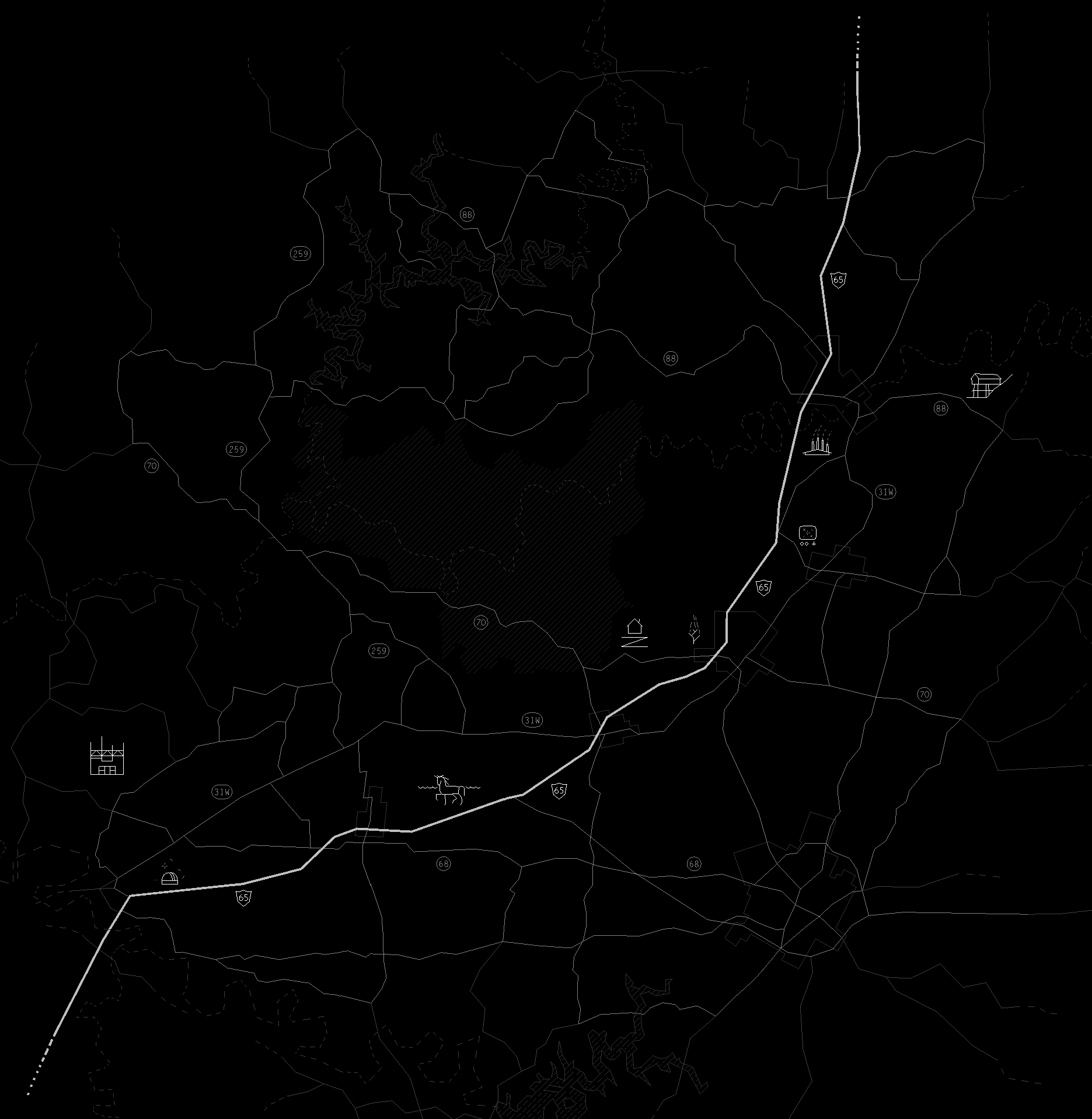
Burning Tree
Artificial Limb Factory
Museum
Bait shop (Shannon's workshop)
Guitar player
Dragonflies (1)
Dragonflies (2)
House (3)
Wreck
Church
Diner
Barren River RECC
Tavern
Observatory
Convenience Store
Picnic
Clockworks
Patty's Home
Linda's Home
Drive-in Theater
Railroad Track
Railroad Track Entrance
Railroad Track Entrance 2
Petting Zoo