Difference between revisions of "Template:Map"
Jump to navigation
Jump to search
m (Nclm moved page Template:Maps to Template:Map) |
m |
||
| (13 intermediate revisions by 2 users not shown) | |||
| Line 1: | Line 1: | ||
| − | <includeonly> | + | <includeonly>:To insert a map, see [[Template:Map]].</includeonly><noinclude>A template for making maps with labels. See [[Maps]]. |
| − | :To insert a map, see [[Template:Map]]. | ||
| − | </includeonly> | ||
| − | <noinclude> | ||
| − | A template for making maps with labels. See [[Maps]]. | ||
== Use == | == Use == | ||
| − | Define a base map layer, choose a display width, and | + | Define a base map layer, choose a display width, and specify the labels. X and Y are percentages. |
| + | |||
| + | The grid layer can be used while editing to assist with positioning. The default grid is white with 20% opacity. | ||
| + | |||
| + | Optional attributes include: (Start) Link; (Label) Color, Length, Width | ||
<pre><nowiki> | <pre><nowiki> | ||
| − | {{Map/Start|base=FILENAME.png|width= | + | {{Map/Start|base=FILENAME.png|width=PIXELS|link=PAGENAME}} |
| − | <!--{{Map/Grid}}--> | + | <!-- {{Map/Grid|color=rgba(255, 255, 255, 1)}} --> |
| − | {{Map/Label|X|Y|Label}} | + | {{Map/Label|1=X|2=Y|3=Label}} |
| − | {{Map/Label|X|Y| | + | {{Map/Label|1=X|2=Y|3=Label|color=COLOR|length=PIXELS|width=EM}} |
| − | {{Map/ | + | {{Map/LabelE|1=X|2=Y|3=Label|color=COLOR|length=PIXELS|width=EM}} |
{{Map/End}} | {{Map/End}} | ||
</nowiki></pre> | </nowiki></pre> | ||
| − | == | + | == Examples == |
| − | + | <div style="overflow: hidden;"> | |
| + | <div style="float: left; margin-right: 2em; margin-bottom: 2em;"> | ||
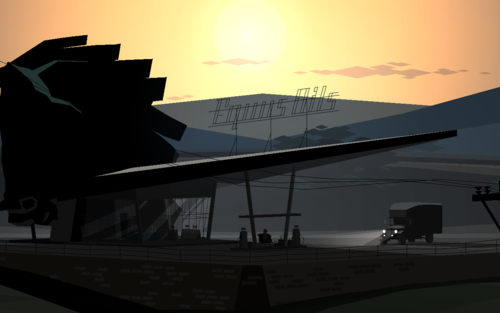
{{Map/Start|base=Equus Oils.png|width=500}} | {{Map/Start|base=Equus Oils.png|width=500}} | ||
| − | {{Map/Label| | + | {{Map/Label|12|36|Horse head|length=20|width=6}} |
| − | {{Map/Label| | + | {{Map/Label|28|71|Computer|width=6}} |
| − | {{Map/ | + | {{Map/LabelE|53|75|[[Joseph]]|length=45|width=4.5}} |
| − | {{Map/Label| | + | {{Map/Label|80|10|Color &<br />multiline test|color=green}} |
{{Map/End}} | {{Map/End}} | ||
| − | + | </div><div style="float: left; margin-bottom: 2em; margin-left: 2em;"> | |
| − | + | {{Map/Start|base=Equus Oils.png|width=500}} | |
| − | + | {{Map/Grid|color=rgba(255, 255, 255, 0.4)}} | |
| − | |||
| − | |||
| − | {{Map/Start|base= | ||
| − | {{Map/Grid}} | ||
{{Map/End}} | {{Map/End}} | ||
| + | </div> | ||
| + | </div> | ||
| − | == | + | == Components == |
* [[Template:Map/Start]] | * [[Template:Map/Start]] | ||
* [[Template:Map/Label]] | * [[Template:Map/Label]] | ||
| + | * [[Template:Map/Grid]] | ||
* [[Template:Map/End]] | * [[Template:Map/End]] | ||
| − | [[Category: | + | [[Category:Map Templates]] |
</noinclude> | </noinclude> | ||
Latest revision as of 10:00, 4 February 2020
A template for making maps with labels. See Maps.
Use[edit]
Define a base map layer, choose a display width, and specify the labels. X and Y are percentages.
The grid layer can be used while editing to assist with positioning. The default grid is white with 20% opacity.
Optional attributes include: (Start) Link; (Label) Color, Length, Width
{{Map/Start|base=FILENAME.png|width=PIXELS|link=PAGENAME}}
<!-- {{Map/Grid|color=rgba(255, 255, 255, 1)}} -->
{{Map/Label|1=X|2=Y|3=Label}}
{{Map/Label|1=X|2=Y|3=Label|color=COLOR|length=PIXELS|width=EM}}
{{Map/LabelE|1=X|2=Y|3=Label|color=COLOR|length=PIXELS|width=EM}}
{{Map/End}}